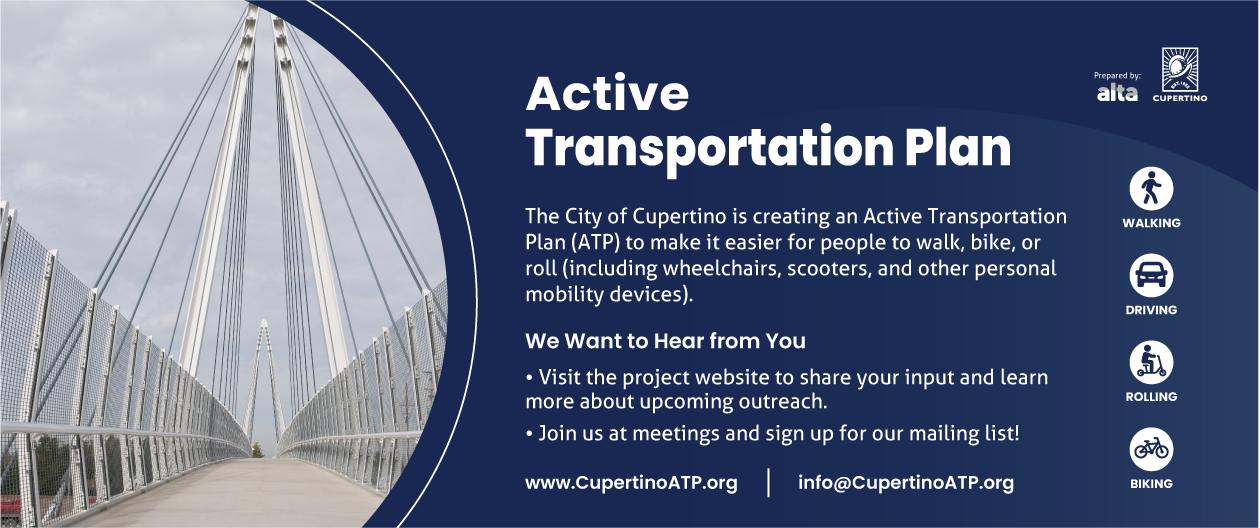
Active Transportation Plan
Project Overview
The Active Transportation Plan (ATP) will prioritize transportation projects that promote active transportation within the City of Cupertino. This includes conducting an inventory of existing infrastructure, developing a focused list of implementation projects, identifying non-infrastructure elements for community engagement, creating a realistic approach to project funding, and conducting extensive public outreach. The project will build on similar past efforts, such as the City's 2024 Vision Zero Action Plan, 2023 Local Roadway Safety Plan (LRSP), 2016 Bicycle Transportation Plan(PDF, 8MB), and 2018 Pedestrian Transportation Plan(PDF, 15MB). By leveraging insights and successes from these previous plans, the new ATP will be comprehensive, informed by past experiences, and aligned with the City's long-term goals for active transportation.
The ATP is fundamentally different from safety-focused plans like the Vision Zero Action Plan and the LRSP. In short, the ATP isn’t just about preventing crashes. It is the go-to document for ensuring Cupertino has the infrastructure, policies, and strategies to make active transportation a central part of everyday life.
While there may be overlap with safety plans, the ATP organizes and consolidates the key findings and primary goals of these other plans to serve as a guiding master plan document for active transportation project delivery. It unifies the priorities of Vision Zero and LRSP while adding the infrastructure and policy frameworks needed to implement capital projects.
Stay involved, join the mailing list, and help shape Cupertino’s future transportation network!
Phase 2: Project Recommendations (Starting August 20)
An updated website and survey tools will be published on August 20. Join the project mailing list to be notified when the updated website goes live!
Learn more about how plans like the ATP help the City deliver projects by clicking on the Completed Projects webpage. While this webpage does not catalog all completed projects, it illustrates how the City implements adopted local plans, such as the ATP, through City Council approval, input from the Bicycle Pedestrian Commission, and community feedback.
Phase 1: Needs Assessment & Existing Conditions (Complete)
Phase 1 ran from March 19 to June 5, 2025, and included 12 outreach events that engaged more than 1,300 community members and generated nearly 3,000 public comments.
This community feedback is playing a significant role in shaping draft project recommendations, which will be further refined and shared in the fall for the community to evaluate. In addition to community outreach, analysis was conducted to assess existing conditions, identify unmet demand for active transportation, and determine where improvements would have the greatest impact.
This data analysis, Phase 1 public feedback, and plan and policy review are guiding the development of draft recommendations for a safer and more connected multimodal transportation system.
Technical memos summarizing the community outreach, policy review, and analysis performed for Phase 1 are available below.
1. Plan Review
The project team reviewed relevant planning documents to establish a baseline understanding of local policies, transportation plans, and networks in Cupertino. This effort included summarizing local and regional plans, policies, and standards that influence active transportation in the City. The review identified the policies and objectives that shape local and regional decision-making, ensuring the Plan aligns with the goals of Cupertino and its partner agencies. This alignment helps the Final Plan balance local goals with regional and state priorities, strengthening project eligibility for grant funding.

2. Community Outreach
Outreach activities were structured to reduce barriers for Cupertino’s residents and visitors by bringing engagement to them, with central community meetings, virtual engagement, and pop-ups at existing community gatherings. The community commented on issues like desired destinations and barriers to walking or biking, concerns related to potential traffic impacts, and other relevant information.
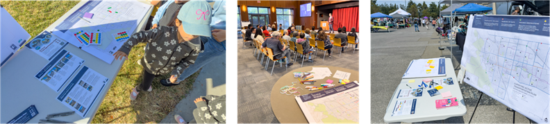
A mobile-friendly project webpage that included an interactive map was published to make community input easier and more convenient.
3. Goal Setting
A set of short-, medium-, and long-range goals and objectives was established to provide a clear vision for walking and biking in Cupertino. The ATP’s vision, goals, and objectives were developed by consolidating similar and overlapping statements from existing Cupertino plans and then refined using the input gathered during Phase 1 outreach to also reflect today's community needs and concerns.
4. Technical Analysis
The technical analysis first consisted of an inventory of Cupertino’s existing bicycle and pedestrian infrastructure to map current conditions and understand potential gaps. The project team then conducted a detailed Needs Assessment by reviewing collision data, using the City’s Vision Zero High Injury Network, and performing a Level of Traffic Stress (LTS) analysis to measure perceived comfort for walking or biking on all Cupertino streets, helping to identify areas where walking and biking might feel unsafe or disconnected.
An Active Trip Potential assessment was also completed to determine where short driving trips could shift to walking, biking, or micromobility. Trip potential analysis is an innovative approach that leverages Replica's Places simulation model to estimate the number and location of short trips that could realistically be completed by walking, biking, or rolling. LTS and Active Trip Potential results were then combined to measure Gap Scores for walking and biking with a Stress-Adjusted Short Trip analysis (SAST). Stress-adjusted short trip analysis quantifies and ranks locations where improvements for walking or biking would have the greatest benefit.

This analysis, along with public input, informed the development of recommendations to ensure that projects are grounded in both data and public comments.
5. Draft Recommendations
The work from the above activities led to the development of draft project recommendations, which will be shared with and evaluated by the community on August 20.
A list of programmatic and policy recommendations was also developed as a result of analyzing the findings from community outreach and plan review. Addtionally, there was significant public interest in Cupertino developing a program to count bicycle users on an ongoing basis. A white paper summarizing the options and considerations required for implementing a count program is linked below.
FAQs
Question: Is the City of Cupertino measuring the effectiveness of transportation improvements?
Answer: Yes. The City conducts before-and-after studies to evaluate the impact of safety and mobility improvements. For example, vehicle travel time studies were performed before and after the installation of buffered bike lanes on De Anza Boulevard. These studies led to traffic signal timing optimization efforts that not only maintained but improved upon pre-project travel times. In addition, the City tracks collision data over time to identify safety trends. However, since Cupertino is a smaller city, measurable safety outcomes may take longer to become evident. It’s important to note that the types of improvements being implemented are based on nationally and globally proven engineering practices.
Question: Why don’t we see immediate safety improvements after changes are made?
Answer: Safety benefits often appear over a longer period, especially in smaller communities with fewer total collisions. Monitoring trends and collecting reliable data takes time, but this is necessary to evaluate long-term effectiveness.
Question: Are other modern safety technologies being considered in Cupertino?
Answer: Yes. Cupertino is exploring a range of safety technologies and innovations, including:
-
Leading Pedestrian Intervals (LPIs): LPIs give pedestrians a head start at intersections. Cupertino has implemented LPIs at several intersections and is exploring further expansion. However, impacts on traffic operations must be evaluated before being implemented at any given location.
-
High-Visibility Crosswalks and Stop Lines: These are installed and upgraded regularly, especially during repaving and restriping projects, to improve pedestrian visibility and reduce encroachment.
-
Automated Speed Enforcement (ASE): Currently only legal in select California cities as part of a pilot program. Cupertino would consider ASE if state law expands authorization.
-
Red Light Cameras: Previously used in Cupertino but discontinued due to cost and effectiveness concerns. The City is monitoring improvements in this technology, particularly those incorporating AI, which may reduce operational demands.
-
Smart/Adaptive Traffic Signals: Cupertino uses adaptive signals along a portion of De Anza Boulevard and is seeking funding to expand this system further. Future deployments will depend on the performance of the current segment and the availability of funding.
-
AI-Powered Safety Analytics: The City is tracking the development of systems that detect near-misses and risky behaviors. These technologies are still in development and not yet widely available or reliable.
-
Pedestrian Beacons: These are routinely installed at locations with demonstrated need to improve driver compliance and pedestrian safety.
-
Automated Pedestrian Detection: The City is monitoring this emerging technology and will consider deployment once solutions are proven safe, effective, and affordable.
Question: How does Cupertino balance safety and traffic flow?
Answer: The City prioritizes safety while also considering traffic efficiency. Improvements are evaluated for both their safety outcomes and operational impacts. Signal timing adjustments, data collection, and new technologies are used to ensure a practical, balanced approach.
Project Schedule
Phase 1: Needs Assessment and Existing Conditions (March to June)
-
Analysis of datasets such as city demographics, land use, infrastructure present and planned, and other relevant inputs.
-
Background review of local, regional, and state policies and plans related to or influencing active transportation.
-
Community engagement to identify current active transportation conditions, barriers, and community needs for the future, establishing a clear vision and goals for the ATP.
Phase 2: Project Recommendations (July to October)
-
Identification and prioritization of infrastructure improvements and programmatic recommendations based on community feedback, existing conditions, and best practices.
-
Development of a detailed financial analysis and implementation strategy, including planning-level cost estimates and funding opportunities.
-
Continued community engagement to refine recommendations and ensure alignment with community priorities.
Phase 3: Draft Plan Review and Final Adoption (November to February)
-
Preparation and public review of a comprehensive, user-friendly draft Active Transportation Plan document.
-
Interactive public feedback opportunities, including presentations to the Bicycle Pedestrian Commission and City Council for final review and adoption.
-
Adoption of the Final ATP based on community input and official approvals.
Community Workshops
In addition to community pop-ups, the project team will be hosting two public workshops during Phase 1 and Phase 2 of the ATP. Phase 1 dates are shown below.
Phase 1 Workshops
Virtual Meeting
Date: Monday, May 5
Time: From 6:00 p.m. to 7:30 p.m.
Meeting Recording: YouTube Link
Meeting Materials: Presentation(PDF, 12MB)
In Person Meeting
Date: Wednesday, May 7
Time: From 6:00 p.m. to 7:30 p.m.
Location: Cupertino Community Hall
Meeting Materials: Presentation(PDF, 12MB)
Phase 2 Workshops
Phase 2 workshop meeting dates are still being determined.
Funding
The project is fully funded through the City's TDA3 direct allocation. The Metropolitan Transportation Commission (MTC) programs TDA Article 3 funds in the nine Bay Area counties.